Showing posts with label trails. Show all posts

Saturday, August 26, 2017

Hiking the Falling Waters Falls trail

Yesterday we went up to the Falling Waters Falls State Natural Area on Signal Mountain in Walden.  I don't remember having parked in that area before, though I thought I have hiked to the top of the waterfall before.


The parking lot has spaces for about 4 cars, maybe 5, depending on size.  It would be nice to have a trash can there on site as there was quite a bit of trash around the parking area and the sign.  We got lucky yesterday.  We were the only ones when we got there and when we left.  We had the trail to ourselves.

The trail is an easy to moderate walk/hike, with the only treacherous portion(s) being when you get to the waterfall area and then continue up and around the bluff.  One needs to use common sense and not get to close to the edge.  It's a long way down.

I kept looking for the big hole in the rock that I remembered from my last time there, but I couldn't find it.  Maybe there is another waterfall/cliff spot on top of the mountain that I'm thinking of or I just couldn't see it yesterday.


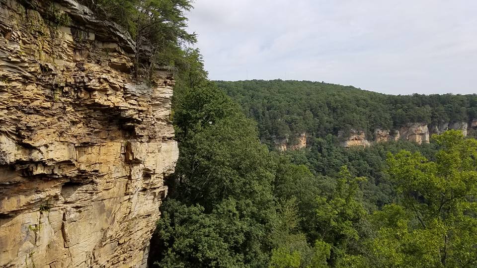
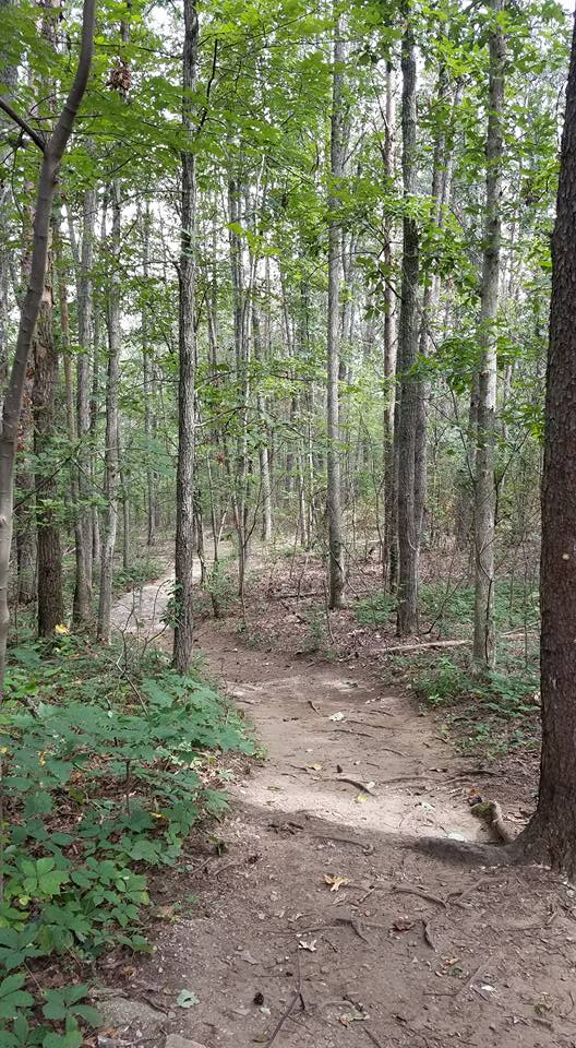
What I could see yesterday was a bubbling creek to the left after we were in the woods for a little bit (no pictures of it).  Then we came out to where the water goes over the rock and down below.  There wasn't much flowing yesterday, so the waterfall was small.  After enjoying the view for a little bit, we headed up the trail along the bluff.  We followed it to the end.  It wasn't as traveled on this part.

There was a rock perfect for standing or sitting to enjoy the view.  You could see the Sequoyah stacks off to the distance on the left and the lake/river too.  Closer in you could see the "new" housing development next to highway 27.  We didn't realize how expansive it was and that they were still building.


I saw different kinds of mushrooms along the trail and took pictures of the ones that were easy to get to.  There were three mushrooms in the woods, lined up together (one in front of the other), shining in the light, but I couldn't quite get to them for a picture.


I enjoyed the tiny flowers along the way too.


There was enough trash along the trail to fill up about two grocery bags full.  I didn't carry any bags with me yesterday and regretted it.  There were some plastic bottles--water and power drinks; there were some aluminum cans--beer; there were cigarette packs-- one even thumb-tacked to a tree; there were glass bottles semi-buried in the leaves-- showing some evidence that the front portion might have been used as a dump at one time and deserves some extensive clean up time.  Though there wasn't too much trash, it was enough to consider a clean up hike to get it out and reminded me of the time I took our youth at First Dayton on a clean up hike on a trail in the Dayton area and shared a devotion "Living Waters" while we were on a rock next to the stream.  That was in the 90s.


The trail itself is short, but one can spend quite a bit of time up there because the scenery is gorgeous and it's a great place to simply "be".

I had left my hammock in the car, but there are plenty of trees for some hanging time too.

After we left the natural area, we went to Guthrie's for some fried chicken and took it to Signal Point for a picnic.  We weren't ready to go back indoors just yet.  It was too nice of a day to call it quits.  The overlook on the point allows for a great view of the river.


There are some rock formations to the left of the picnic pavilion and we enjoyed those for a few moments.


Though we looked at the hiking pavilion, we didn't do any more hiking.


If you're interesting in checking out some of these local areas, I'll include links at the bottom.

Getting outside and into the woods is an important part of my journey.  It gives life to my soul, expanding the breathing space, allowing me to listen to God, refreshing me, and strengthening my connection with the Creator.

Blessings on your journey,

Debra

Falling Waters Falls State Natural Area
Signal Point
Guthrie's Chicken
Cumberland Trail State Park (Signal Point trails are part of this trail)

Friday, May 30, 2014

Stringer's Ridge Trails.... a gorgeous morning


This morning we walked/hiked up at Stringer's Ridge.  This area is newly renovated and opened to walkers, bicyclists, and runners.  In order to avoid collisions on the paths, there are directional instructions based on the day of the week for the different outdoor enthusiasts.


We started at the Spears Trailhead.  The trailhead parking area provided a good 10-12 parking spaces, a picnic table, a large map of the area, and a port-a-john.  The trail markings were abundant and clear.  In fact, I haven't seen a trail system so adequately marked.  That was refreshing to see.  Click here for a map of Stringer's Ridge.


During our adventure we encountered two snakes, a turtle, a runner, some other walkers, a woman with a stroller full of kids.  It was overall fairly quiet for a Friday morning outing.


The highlight very well could be the overlook.  They have done a tremendous job on this overlook.  There are three block benches for seating on the structure that goes out over the drop off.  The view is gorgeous.   Though a little hazy this morning, one could still see downtown well.


Being on the trail with a botanist and his number one sidekick means that I got to learn new things today.  I saw native magnolia trees.  Their leaves are HUMONGOUS.  Not the magnolia trees I grew up with in my yard nor that my grandmother had, which I learned are native to Mississippi.  I saw Japanese grass, Kudzu, tick weed, funky fungus that turned out to be elegant stinkhorn (Mutinus elegans), the fruit of the may apple, Christmas fern that looked that a stocking (though I thought it looked like an oversized mitten), etc.  Some things I had seen during my spring walks and had learned, but had not seen in this state.  The indian pink was beginning to shrivel and fade away. 

elegant stinkhorn

mushroom

May apple

Ginger, little brown jug, pig's nose

tick weed

It was good to be out in creation, walking along the paths in the woods.  The majority of the paths we walked were in the woods, though some were the gravel roads which are remnants of the roads and driveways from the neighborhoods from days gone by. 

If you live locally and haven't checked out Stringer's Ridge, I encourage you to do so.

If you are planning to come to the Chattanooga area and you are looking for a place to hike, check it out.

Lastly, I saw this quote today on Facebook on the Shalem Institute site by Gerald May and it fit very well for today:

"In order to let God lead, you have to be relatively free from the things that normally determine your thoughts and actions. I find it best to be outdoors, away from the habits of household and civilization. Familiar surroundings always seem to demand certain activities from me. I sit a certain way in a chair, act a certain way in a room, think along particular lines in a particular place. Outdoors, especially in a fairly wild place, I'm much fresher, more immediately available for whatever inspiration might come."

Today's walk/hike outdoors was definitely refreshing.  And with the snakes and turtle sighting (and the odd plant life), there was some "wild" involved.   Maybe as I walked those paths, God was working and leading inwardly in my heart, mind, and soul.  Who knows?

Blessings on your journey,

Debra
covered avea.. looked cool

erosion at beginning of Spears Trailhead
 

trail

graffiti on the concrete block foundation
 
Christmas fern

magnolia leaves
 
More links about Stringer's Ridge:

Article in Times Free Press, September 2013
Friends of Stringer's Ridge Facebook Page
The Trust for Public Land-- Stringer's Ridge


Friday, May 16, 2014

Dam Hidden Treasure... why can't it be re-opened for all?

No, the title doesn't contain a misspelled word.  The "dam" I am referring to is the Chickamauga Dam in Chattanooga, TN.  The "hidden treasure" I am referring to is the recreational area known as North Chickamauga Creek Greenway that is not really "hidden" but blocked off from access on the dam side.  The North Chickamauga Creek Greenway is currently ONLY accessible via the Greenway Farms off of Hamill Road (and Gann Store Road) in Hixson.  The sign below is on the dam side of the Greenway, the portion that is currently blocked off from Lake Resort Drive.


To access this portion of the Greenway, you must park at the Greenway Farm on the Hixson side and walk, run, or jog to the other side.  Since this includes going up hill to the quarry area, this isn't feasible for anyone needing wheelchair or walker access.  I have seen folks pushing baby buggies up the hills and through the area though.
 
The good news is that THERE IS access for those needing to use a wheelchair or a walker on the dam side.  There is even parking designated for those who have the required parking tags.
 
 
For the most part, this area of the Greenway is kept up rather well considering one cannot access it from the dam side.  The workers keep the restroom facility in order, the trails clear, and the grass mowed.  There is some work that would need to be done if this facility were to be reopened.
 
And that is my point in writing.  WHY ISN'T THIS FACILITY OPEN?!?!?  It was originally closed because of the dam work on the lock.  However, that work is now on hold.  I don't understand why the access on the dam side to the Greenway couldn't be reopened until the dam lock work starts back (whenever that might be). [See link at bottom of post on the dam and lock.]
 
The lower loop trail is fully accessible for a wheelchair or a walker, even a cane.  But, if someone didn't want to use the trail, there are picnic tables in addition to the big picnic pavilion (seen top left in the photo of the handicapped parking spots and by itself below).
 
 
To my knowledge, this inaccessible location is the only handicapped accessible trail located in the woods (with labeled trees) in the Chattanooga area. 
 
But it's not just for folks needing those facilities, it is a wonderful place for all people to enjoy.
 
There are grassy areas for kids of all ages to play.
 
There is access to the water via these steps.
 
 
And, of course there is the walking trail.  There are several choices.  There is the lower loop, the upper loop.  The Boy Scout trail is also accessible from this side.   One can even take the trail to the quarry if one wishes.   Here is a map of all the trails at the Greenway Farm.
 
However, IF one wishes to enjoy the picnic pavilion on the dam side, one must walk from the Hixson side.  Don't get me wrong.  I enjoy the Hixson side of the Greenway Farm.  There is much to offer on that side too.  There are wonderful open spaces to run and play.  There is the Wildflower Trail.  There is the dog park.  There is the rental facility (former home).  There are walking paths.  But, it's not very user friendly for folks who might need to use a walker, a cane, or especially a wheelchair.
 
At this point in my life, I'm okay with the walking all the way over to get to the hidden treasure.  Yet, if I need knee surgery again.... or if I need hip surgery.... or if I become dependent on a cane, a walker, or a wheelchair..... I would like to be able to enjoy the beauty of this spot.  And it isn't just about or for me.  I think about this property that is sitting unused by the majority of our community because they simply can't get to it easily, whether they need the accessible areas or not.  Families with young children, anyone with injuries, groups that would like to use the pavilion, ETC.
 
City of Chattanooga, if we are not moving forward with the work on the dam lock, then why can't this area be opened up on the dam side?
 
It's a beautiful place!  I hope the blocks will be removed in the near future so that more people in the community can use this place as it was intended to be used and as many of us used it in the past.
 
Maybe folks aren't bothered about this portion of the Greenway not being open to the public.  Maybe folks are okay with it being shut down and inaccessible to the community.  That's cool.  But, there might be a few folks that didn't even realize they were missing out on such a wonderful hidden (blocked) treasure.  Maybe, just maybe, someone that can re-open the road (or at least explain why it won't be re-opened) will somehow hear the message and respond.
 
 
Walking onward on the journey,
Debra
 
MORE PICTURES:
 
 
Newly renovated benches on the dam side of the trail; overlooks a rope swing and the creek.
This bridge begins the walking trail on the dam side, from the parking lot.
 
Check out the links below for additional information:
 
 
Information on the Boy Scout Trail from the North Chick website:
 

Length: Approximately 1.3 miles
Difficulty: Moderate to Difficult
Uses: Foot Traffic Only
The Boy Scout Trail is located within TVA’s Big Ridge Small Wild Area. The trail makes a loop, going to the top of Big Ridge and back down to the Greenway. The entirety of the trail is dirt singletrack, and it goes through some of the oldest forest in the North Chickamauga Creek watershed.
Access: The Boy Scout Trail branches off of the North Chickamauga Creek Greenway about 0.7 miles from the parking lot next to the Outdoor Chattanooga barn. Take the Greenway up and over the quarry and past the Upper Loop. The Boy Scout Trail is the first trail on the left past the southernmost turn-off for the Upper Loop.


Information on the dam and lock from the US Army Corps of Engineers

Article in Chattanooga Times-Free Press, January 30, 2014 about the lock and dam